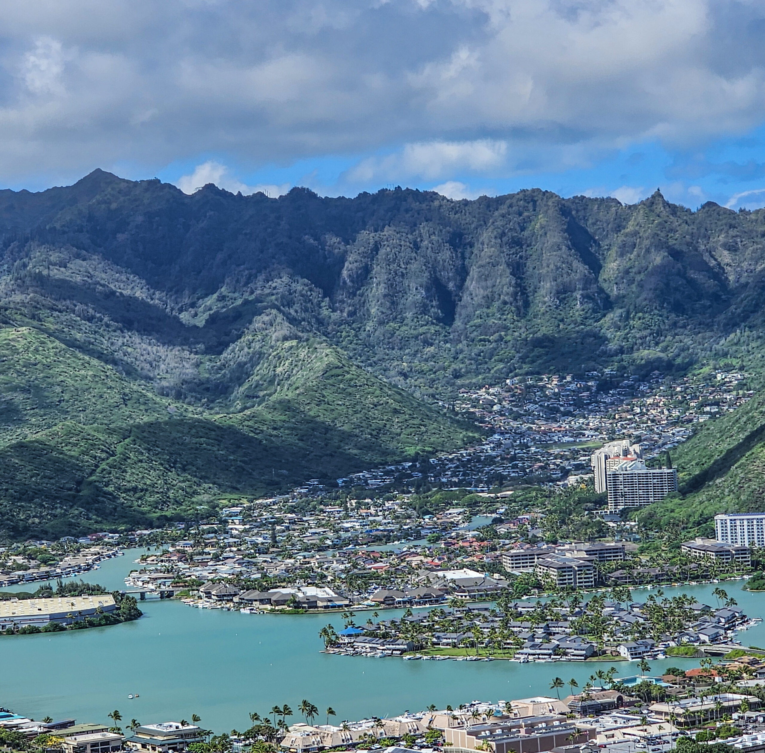
HARD is a grassroots organization of Hawaii residents concerned about the land uses and development from 6640 to 6660 Hawaii Kai Drive, between Pepeekeo Street (7-11) and Hahaione Streets, due to the upcoming lease expiration.
WHAT IS OUR MISSION?
HARD is a grassroots organization working to protect and preserve Hahaione Valley’s environment and view plane mauka of Hawaii Kai Drive between Pepeekeo and Hahaione Streets, and to maintain Hawaii Kai’s safe, peaceful and quiet residential character, healthy environment, outstanding urban tree canopy, and excellent quality of life.
WHAT IS HARD’S BUSINESS STRUCTURE?
HARD is a fully voluntary grassroots effort made up of neighbors with various backgrounds, but connected through our love for the community and commitment to the future of the valley.
HARD has no paid employees, lawyers, architects, consultants, contractors, public relations team, cultural experts, or lobbyists. Therefore, we welcome additional volunteers and their various
skills and talents.
Yes. HARD invites and urges a collaborative inclusion of all community voices at the outset of and throughout the development decision-making process. HARD envisions a continuation of Hahaione Valley’s residential character with its diverse demographics, ethnicities and cultures of
people who peacefully co-exist and call Hahaione Valley home.
Absolutely. Anyone who supports development that respects and protects the residential character of Hahaione Valley is encouraged to sign the petition, attend public meetings and volunteer. There are HARD members who do not reside in Hahaione Valley but own properties
or have relatives and friends there; who are involved with respectful development efforts in other Hawaii Kai neighborhoods whose KSBE leases will soon expire; and/or who support environmental, sustainability, and other causes compatible with HARD’s mission.
Visit www.HahaioneAdvocates.com periodically for any new information on development plans.
As we learn more, the site will share updates and how or where to:
Volunteer
Circulate the petition
Walk door-to-door
Drop flyers
Attend public and HARD meetings
In Hahaione Valley, the affected commercial properties are located from 6640 to 6660 Hawaii Kai Drive between Pepeekeo and Hahaione Streets. 7-11, the gas station and Boston Pizza are on one parcel; the middle parcel is the Koko Head Plaza with numerous small businesses, churches, and the pet clinic; and the third parcel is the former Japan-America Institute for Management Sciences’ (JAIMS) two-story building that is mostly hidden by a grove of mature monkeypod trees.
Yes, JAIMS directly borders the school. Further, Hahaione Elementary School and Hahaione Community Park border the entire mauka boundaries of the JAIMS parcel. The Village Green townhouses on Pepeekeo Street lie between the 7-11 and Koko Head Plaza properties and the school.
The Village Green townhomes on Pepeekeo Street, which are a mix of fee simple and leasehold properties, are directly adjacent to all three commercial properties from 7-11 to the JAIMS building. KSBE holds the land lease for Village Green’s leasehold townhomes. The maximum
building height for these townhomes is 40 feet.
Also, there are hundreds of multi and single-family residences directly feeding onto Hawaii Kai Drive that could be affected by new or more intensified development on the affected commercial properties.
According to the Department of Planning & Permitting (DPP), the three commercial parcels bordered by Hawaii Kai Drive are zoned as B-2 Community Business District with a maximum building height of 60 feet.
You may also hear the language “Land Use Ordinance” or “LUO” when developers and the media refer to legal zoning designations.
The current commercial businesses include 7-11, a gas station, Boston Pizza, and the Koko Head Plaza office building with numerous small businesses, churches, a yoga clinic and pet clinic.
The tree-covered JAIMS building near Hahaione Street is owned by Fujitsu Limited, which built and established JAIMS as a nonprofit corporation to provide international post-graduate educational programs since 1972. However, JAIMS was dissolved as a nonprofit corporation in
2024 and Fujitsu Limited is winding down its operations at the JAIMS location. An international preschool still subleases part of the JAIMS building.
The land underlying all three properties is owned by Kamehameha Schools Bishop Estate (KSBE). The land leases are currently set to expire in 2028. There is a possibility that a lease may be voluntarily terminated sooner if both KSBE and the lessee agree.
The current tenant mix on the three parcels serve useful community purposes and complement the quiet residential character of Hahaione Valley. While each affected parcel has their own unique needs, one proposal that HARD supports with respect to the JAIMS property is to convert it into a community center that could retain the international preschool, which has indicated it would like to extend its lease at the JAIMS building. As we have heard from the community, there are many other potential tenants who could occupy the remainder of the building, such as a charter school, other educational entities,
churches, or nonprofit organizations. While there are many other good ideas for uses of the property that residents have shared with us, we would respectfully ask KSBE to lay the foundation for these ideas by converting the existing JAIMS building into community center that
can house community organizations, programs, or activities for free or reasonable rents.
Because the JAIMS property adjoins the Hahaione Elementary School and Hahaione Community Park, a multi-cultural, multi-use community center could serve keiki to kupuna from all of Hawaii Kai and nearby communities, including Kuliouou, Kamilonui and Kalama Valleys and
surrounding residential neighborhoods. A community center or multi-use gathering space would also be consistent with HARD’s goals and the East Honolulu Sustainable Communities Plan.
HARD would consider supporting other proposals for respectful development of the JAIMS and adjoining properties/parcels that are also compatible with our mission. Additionally, a year-round community center at JAIMS could also serve as a community resiliency hub to better prepare our community for the natural disasters that are occurring more frequently as a result of climate change and challenges.
A community resiliency center has been defined as a “trusted gathering site or group that supports year-round community resilience and during a disruption “activates” to support a coordinated response.” Year-round, a hub can benefit the community in a variety of ways, such as by providing educational programs for keiki to kupuna, arts and multicultural activities, and meeting spaces for volunteers, community organizations and
churches, as well as preparation and training for disasters, or stockpiling of emergency food, water, and medical supplies. During and after disasters, a hub should be prepared to quickly respond, which might include providing temporary shelter, emergency and volunteer coordination, first aid or cell phone charging, food and water
distribution, and information about local resources and the needs of vulnerable community members. Additional post-disaster assistance could be provided at hubs by government and other organizations, such as applying for federal emergency (FEMA) assistance, flood insurance, or small business loans; replacement of important documents like drivers licenses or passports; and holding community informational
meetings.
The North Shore community benefited after the March 2026 Kona low storms from the quick action of its community resiliency hub that quickly mobilized volunteers to help impacted residents with emergency recovery needs and worked with government and other organizations to provide additional post-disaster assistance.
East Honolulu’s main transportation artery, Kalanianaole Highway, is vulnerable to flooding during extreme weather events, which could prevent evacuation from communities, hamper disaster response efforts, and cut off communities like Hawaii Kai from the rest of the Honolulu urban core. Establishing a community resiliency hub in Hawaii Kai could better prepare everyone for emergencies, efficiently coordinate
resource distribution and services during disaster response and recovery, and provide an organized center for disaster preparation and response, along with alternative access to East Honolulu from the Windward coast if Kalanianaole Highway was damaged. Moreover, because Hawaii Kai (i.e., Maunalua, and including Portlock,
Kalama Valley, the golf course area) constitutes about half of the East Honolulu district and has many residences located along its inland waterways and shoreline areas, there is actually a need for more than one community resiliency hub in the Hawaii Kai area.
Consistent with the EHSCP and Ola Oahu Resilience Strategy, the JAIMS building would be ideal as a community center to provide services throughout the year as well as be a community resiliency hug for pre- and post-disaster preparation and response.
The two-story JAIMS building is over 36,000 square feet inside, with an international preschool currently using about half of the first floor. It is large enough to be used for a variety of purposes, even if the preschool is allowed to continue there. Besides pre-disaster preparation, training, or community educational programs, the JAIMS building could be used year-round for various other purposes suggested by the public, which
HARD’s online survey is gathering.
The JAIMS building is centrally located in a residential area close to large numbers of residents who could be adversely impacted by flooding or other disasters, and it is directly adjacent to a City neighborhood park and Hahaione Elementary School, which could also be made available during an emergency. Barring a 1-in-1000-year extreme tsunami, Hahaione Elementary School, the park, and the JAIMS property might be the only quickly accessible evacuation areas for those living nearby in the many residences along the waterways and shoreline, especially since alternative evacuation sites in Hawaii Kai could become inaccessible or filled by residents closer to those locations.
Moreover, it is important to preserve the JAIMS building built in 1972 due to its historic significance, and the substantial environmental and health benefits provided by its magnificent trees, which naturally clean our air by absorbing carbon, cool the building and our urban area, reduce stormwater damage to our reef, and provide physiological and emotional benefits for people.
High rises or facilities with 24/7 activities, such as a major supermarket, are not respectful or suitable for any quiet residential area, including Hahaione Valley. The 7-11 to JAIMS parcels have been designated a Neighborhood Commercial Center by the East Honolulu Sustainable
Communities Plan (EHSCP) to serve the nearby residents and not be a regional attraction, and HARD will advocate for this designation to be respected.
More intensive commercial development, according to the EHSCP, would be best situated in the Regional Town Center, which is generally the Hawaii Kai Shopping Center (Safeway, Longs, etc.), the Hawaii Kai Towne Center (Costco, Ross, City Mill, etc.), and the Hawaii Kai Executive
and Medical Plazas (Kaiser Permanente, Roy’s, Satellite City Hall, etc.) on Keahole Street, as well as the Koko Marina Shopping Center on the corner of Kalanianaole and Lunalilo Home Road. The Regional Town Center serves a wider population beyond Hawaii Kai, and it is easily
accessible from Kalanianaole Highway without forcing traffic to drive through and disrupt the quiet residential areas in Hahaione Valley.
We have learned from the experience of Kahala residents on the mauka side of Waialae Avenue across from Kahala Mall, who complained to the Waialae-Kahala Neighborhood Board about noise and light pollution from the relatively new strip mall where Foodland’s Kahala Market, other stores, restaurants, and businesses are located. A full service, large supermarket is a 24/7 business with heavy vehicular traffic that would endanger pedestrians, especially a location with schools next door, such as Hahaione Elementary School. A supermarket’s 24/7 air conditioning
and cooling systems, refrigeration systems, lighted parking lots, and delivery trucks’ exhaust and back up warning signals, will transfer noise and light into the community throughout the day and night.
Moreover, the additional traffic generated by patrons from other areas who must drive deep into Hahaione Valley to go to a major supermarket will significantly impact pedestrians and all the residential driveways and side streets attempting to access Hawaii Kai Drive. Rather than our
quiet Hahaione Valley residential neighborhood, a better location for a full-service supermarket would be in the Regional Town Center located on Keahole Street or at Koko Marina, which have easy access from Kalanianaole Highway for patrons from other areas.
The affected commercial parcels border the only two streets in and out of the valley for the thousands of existing residents and the Hahaione Elementary School, and more new residents on the affected properties will worsen traffic backups on Hawaii Kai Drive and Pepeekeo and
Hahaione Streets, and ultimately, Kalanianole Highway. We are already experiencing traffic backups and pedestrian safety issues in Hawaii Kai, which will not be resolved. For example, at the May and June 2025 Hawaii Kai Neighborhood Board meeting, a Department of
Transportation d representative reported on the dangerous traffic issue in existence by Koko Marina Shopping Center. The spokesperson offered six alternatives to fix the problem but reported they all are too expensive so nothing will be done.
Additionally, the three affected parcels dominate the Hahaione Valley view plane. KSBE, its lessees or a new owner could situate a high rise in the center of this limited view plane area, contrary to Henry Kaiser’s original development plan to keep high rises (like the existing tall
condominiums) next to the base of Mariner’s Ridge.
Although increased density by adding high rises for housing or commercial development may be appropriate in other areas with sufficient infrastructure, such densification is not appropriate in
Hahaione Valley as Hawaii Kai already lacks sufficient power, sewage, water, traffic, and public service infrastructure to support significant increases in population and there is no rail that will alleviate the traffic on Kalanianaole Highway and into Hawaii Kai. Moreover, the East Honolulu
Sustainable Communities Plan, recognizes that East Honolulu is already near housing capacity and has lands zoned for housing to potentially provide less than 300 new residential homes – from Kahala to Hawaii Kai – with only 28 units specifically identified for Hawaii Kai. Table 2-1:
Potential Housing Within Community Growth Boundary on Lands Zoned for Residential Use.
More intense development of these properties would result in increased traffic, which could adversely affect access to the only two streets in and out of Hahaione Valley. Increased traffic would make it more difficult for the many side streets and home driveways to access Hawaii Kai
Drive, especially during rush hour periods or potential emergencies. Increased development may also add to increased traffic along Kalanianaole Highway during rush hours, thus impacting all of
Hawaii Kai and neighboring communities. Of critical importance is the potential increased danger to the children and children and parents who walk or ride bikes to and from Hahaione Elementary and nearby preschools daily.
Existing traffic problems are not being fixed, so increased traffic would only make the problems worse. For example, regarding the Koko Marina Shopping Center traffic problems, a city department representative reported to the Hawaii Kai Neighborhood Board at its May 2025
meeting that six potential solutions are all too expensive and so nothing will be done.
The possibility of a wildfire in Hahaione Valley could have become a reality on March 3, 2025, when two utility poles on the ridge above Kulani Street fell and arced. On May 1, 2025, Hawaii News Now ran a story on two downed electric poles, and many neighbors witnessed the
electrical arc. They expressed concern had this occurred during our islands’ annual dry season, and if not for the recent rains and wet vegetation March 3, a wildfire could have spread in Hahaione Valley. Hahaione Valley is surrounded by mountains covered in highly flammable
haole koa, which grow next to residential lots, and is lined with utility poles, and thus a wildfire could quickly consume homes and spread urban fires throughout the valley. At least one brush fire actually occurred in the past in the nearby Kamiloiki area.
Hahaione Valley has also experienced disastrous flooding in the past, with the December 31, 1987 New Year’s Eve flood that flooded homes at the top of Hahaione Street and gouged out the bottom entrance to the valley and disrupted the entire neighborhood’s traffic patterns.
The condos and townhouses at the base of Hahaione Street have a total of 623 units, which means that there are potentially over 1,000 vehicles that could be trying to get onto Hahaione Street to turn onto Hawaii Kai Drive during an emergency. There are an additional 392 units in the condos from the Heritage House to the Plaza which feed onto Hawaii Kai Drive. Intensified new development on Hawaii Kai Drive between Hahaione and Pepeekeo Streets would adversely impact emergency services into and evacuation from Hahaione Valley via its only two vehicular access points, which is a recipe for disaster during a major wildfire or urban fire, flood, or other calamity.
Moreover, in the event of a tsunami, homes close to the shoreline and inland waterways must be evacuated. Leaving Hawaii Kai via flood-prone and grid-locked Kalanianaole Highway would not be advisable, so these people will likely evacuate to higher ground and public shelters within Hawaii Kai. Alternative evacuation sites such as Kaiser High School and the Koko Head District Park could be filled by people living closer to those areas. Thus, except in the rare event of an extreme 1-in-1000-year tsunami, the JAIMS property and adjacent Hahaione Elementary School and neighborhood park located more than one mile inland from the shoreline could be the most quickly accessed potential sites for evacuees in the Hahaione Valley area to gather and obtain pre- and
post-disaster assistance. Instead of creating new and bigger problems with more intensified redevelopment of the JAIMS property, its conversion to a community center/resiliency hub would greatly help with emergency evacuation needs and disaster preparation and recovery.
Increased traffic and development results in increased air and noise pollution and urban heat, especially if the grove of monkeypod trees on the JAIMS property at 6660 Hawaii Kai Drive is destroyed. It has been estimated that a mature monkeypod tree with a crown diameter of 49 feet absorbs 28.5 metric tons of CO2 annually, and the JAIMS property has at least 20 large monkeypod trees, not including its more than 30 smaller trees. The loss of this community forest and the increased traffic would mean less carbon sequestration and natural beauty, more air and
noise pollution, and a hotter urban area, which could also reduce property values. Loss of the trees would also contradict the government’s ongoing attempts to expand urban canopies, which
was supported by a $42.6 million grant to Hawaii organizations in 2024 and Governor Green’s proclamation of 2025 as the Year of Our Community Forests.
If a large, full-service supermarket, which has been mentioned as a potential development, or other more intense commercialization of the properties occurs, there will be noise from increased traffic and deliveries throughout the day, including early mornings and late evenings, with trucks beeping as they back up, noisy refrigerators, exhaust, and air conditioning compressors running 24/7. Residents in nearby homes and high rises and students at Hahaione Elementary School would be adversely affected by the noise, as many of structures were built to freely capture Hawaii’s trade winds through open windows and residents often do not have or want to use air conditioning.
The lights from the parking areas and new businesses resulting from intensified development will increase visual pollution at night, as experienced by residents behind and nearby the relatively new strip mall on Waialae Avenue across the street from Kahala Mall.
Extensive new development will present a strain on the current sewage, water and traffic infrastructure, and our power grid which already is at the “end of the line” and subject to frequent blackouts.
Depending on the extent of new development and especially during construction periods, children at the preschool at JAIMS and the Hahaione Elementary School abutting the property may face new health, safety, and learning concerns from increased automobile traffic, air and
noise pollution, and crime caused by increased densification. There are additional preschools nearby in the Koko Head Plaza and next to the Oahu Club.
The existing high-rise condos in Hawaii Kai were intentionally planned and built against the mountains to protect and not block the view plane from Hahaione Valley. In contrast, if high-rise buildings are constructed on the commercial parcels located at 6640 to 6660 Hawaii Kai Drive
between Hahaione and Pepeekeo Streets, they would dominate the main view plane to the ocean from Hahaione Valley, where single-family homes have been built since the 1960’s. The view into the valley looking mauka would also be obstructed.
HARD understands that there will be different challenges requiring different solutions for each property. With respect specifically to the JAIMS property, HARD would welcome its continued use as an educational facility by KSBE for its native Hawaiian beneficiaries. But if KSBE decides to sell or lease the JAIMS property to a third party, HARD has heard many great ideas for programs and activities that could take
place there if it was converted into a community center of some sort. HARD supports Council Chair Tommy Waters’ efforts for a long-term lease or purchase of the JAIMS property to create a community resiliency hub for disaster preparation and response while also using it year-round as a community center that could provide government services and other activities desired by the community. HARD would also consider supporting other proposals that are compatible with HARD’s
mission “to protect and preserve Hahaione Valley’s environment and view plane mauka of Hawaii Kai Drive between Pepeekeo and Hahaione Streets, and to maintain Hawaii Kai’s safe, peaceful and quiet residential character, healthy environment, outstanding urban tree canopy, and excellent quality of life,” and the petition requesting:
(1) The landowner Kamehameha Schools/Bishop Estate (KSBE) preserve and maintain the JAIMS building and trees at 6660 Hawaii Kai Drive.
2) Any governmental entities not approve plans or permits to allow for an increase in the current buildings’ height or the removal or destruction of healthy trees over 25 feet tall on the properties located mauka of Hawaii Kai Drive between Pepeekeo and Hahaione Streets.
Yes. We are following the East Honolulu Sustainable Communities Plan (EHSCP), which was developed with extensive community, elected and government official input, and adopted in 2022 by the City and County of Honolulu to set forth and implement the vision for the area from Waialae Nui Gulch to Makapuu. HARD also supports the Ola Oahu Resilience Strategy that was developed in conjunction with the EHSCP. These plans and our summary of the EHSCP may be found on our Plans, Initiatives & Resources page.
ABOUT KSBE, POTENTIAL DEVELOPMENT PLANS, AND THE JAIMS PROPERTY
At the November 2024 Hawaii Kai Neighborhood Board (HKNB) meeting, KSBE was scheduled to present its plans for the numerous east Honolulu parcels with leases soon to expire.
At the meeting, however, KSBE’S spokesperson stated that they were not ready. Although HARD representatives have subsequently met with KSBE, there has been no disclosure by KSBE of any plans for development of its properties in East Honolulu.
At pre-2024 meetings where KSBE presented, its spokespeople had said it would share its Kamilonui Valley plans at the November 2024 Hawaii Kai Neighborhood Board (HKNB) meeting. At the November meeting, however, KSBE’s spokesperson stated it had no plan to present and would only say that they are negotiating individually with the lessees. During the HKNB meeting, community testifiers alleged that KSBE had said for years it would share its plans, but instead it repeatedly returns to the community with no plans. Community testifiers also alleged that KSBE notifies the community after its lands have been leased or sold, at which time KSBE claims that it is no longer responsible for the development plans of those properties.
At the May 27, 2025, HKNB meeting, a Kamilonui Valley farmer testified that she had been offered by KSBE a one-year extension until June 2026 of her land lease, subject to being able to meet various conditions and only on a month-to-month basis, which makes it hard to plan for the
future. She further testified that having her lease potentially terminated in June 2026 is especially problematic because much of her income comes from poinsettias harvested at the end of the year. Since then,
this farmer has been given a one-year “license,” not a long-term lease, to continue farming in Kamilonui, which continues to make it problematic to obtain loans or to make long-term plans.
See the Hawaii News Now article about this issue: https://www.hawaiinewsnow.com/2025/06/18/five-east-oahu-valley-farms-close-when-50-year-leases-expire-end-june/
HARD is working proactively to have the Hahaione Valley community included in a transparent planning and decision-making process from the beginning, and to ensure that any new development will respect our community’s needs and vision. We do not want to be like the
Kamilonui families and farmers who said they were not shown any KSBE plans before their leases expired in May 2025 and have now been left in limbo without the ability to make their own long-term business or personal commitments.
While we hope the development process will be respectful and transparent, we are prepared to factually correct developers’ claims that are inconsistent with the community’s views. Based on news reports about land lease expirations and other developments in Hawaii, developers hire lawyers, public relation teams, engineers, architects, lobbyists, and paid cultural spokespersons to legitimize their development plans and to seek government funding, permitting and zoning (building requirement) changes, as well as receive entitlements. Using select, anonymous “community stakeholder” meetings and/or surveys, developers often state that the community is neutral or supports the development plans.
The thousands of people who have signed their names to our petition already demonstrates that our community does not support high rise or more intensified development of the affected commercial parcels. If you have not already done so, please sign the petition online here.
Yes. The building height could be increased if the City Council and Mayor allow zoning variances or grant entitlements at the request of KSBE, its lessee, land purchaser or developer.
If, however, the East Honolulu Sustainable Community Plan is to be followed, then zoning changes (such as from Commercial to Residential or Mixed Use) would require an Environmental Assessment or Environmental Impact Statement, along with an examination of the sufficiency of infrastructure to support the change. HARD’s efforts, with your help, will be a strong voice in opposition to any variance, entitlements, or zoning changes. We will inform you as soon as possible via our website or email if we learn of any such attempts.
No. HARD honors and reveres KSBE’s cultural and educational contributions. We support KSBE’s website statement to promote “culture, ōlelo, and āina-focused opportunities for community” as well as its Maunalua Vision Statement: “Maunalua is a vibrant community
connected by kai and wai, where keiki to kūpuna thrive in a sustainable blend of agriculture, housing, commerce, open space, and wahi pana.”
We are hopeful KSBE’s statements and the Hahaione community’s input will help direct KSBE’s plans – or its land purchasers or lessees’ – vision for the commercial properties on Hawaii Kai Drive between Pepeekeo and Hahaione Streets. Specifically with respect to the JAIMS property, we are advocating for a year-round community center to be established there, which could also serve as a much needed community resiliency hub for disaster preparation and response in Hawaii Kai.
HARD understands KSBE’s rights as a landowner, and our community group hopes that KSBE as Hawaii’s largest private landowner will respect and include the voices of the people and businesses being impacted before it directly or indirectly develops its properties through future leases or sales. Ideally, HARD hopes that KSBE will work with it to convert the JAIMS building into a year-round community center, which
could house, on a shared or full-time basis at free or affordable rents, educational, multicultural, environmental, religious, or other nonprofit organizations that are compatible with HARD’s mission and petition, while also serving as a community resiliency hub so that our community can better prepare for and respond to future storms, tsunamis, and other disasters.
The landscape architect for the Japan-America Institute for Management Sciences (JAIMS) property was Robert M. Fujiwara. Long before Governor Ariyoshi’s wife, Jean, began the 1985 campaign to plant “A Million Trees of Aloha,” over twenty monkeypod trees and dozens of
smaller trees were planted to shelter the JAIMS building and create a community forest.
According to one study, a mature monkeypod tree with 49-foot crown diameter sequesters approximately 28.5 metric tons of carbon annually. Therefore, we roughly estimate that the JAIMS monkeypod and other trees absorb over 600 metric tons of carbon each year.
While Hawaii and the world have been reaching new heat records, tree canopies help to cool urban areas, combat air and noise pollution, recharge the water supply, and provide physiological and emotional benefits to improve overall health. Communities with more trees are not only cooler, but they also tend to have higher income levels and property values. In 2024, the federal government granted $42.6 million to Hawaii organizations to expand the urban tree canopy, especially in disadvantaged communities. Rather than cutting the JAIMS trees down and releasing the carbon held within, it is much more efficient and climate friendly to sustain them.
Governor Josh Green has proclaimed 2025 to be the “Year of Our Community Forests.” https://dlnr.hawaii.gov/blog/2025/01/10/nr25-007/
The JAIMS property is a living example of what a mature community forest can look like, which Governor Green also recognized in his Proclamation celebrating the “90th Anniversary of Fujitsu Limited” on June 20, 2025 and thanking the company for its support of JAIMS for over 50 years.https://hahaioneadvocates.com/wp-content/uploads/2025/06/2025-0620-Fujitsu-90th-Anniversary_-Final-Print-Ready-2-1.pdf
The Japan-America Institute for Management Sciences (JAIMS) was a non-profit educational institution founded in 1972 by Fujitsu, Ltd. of Japan. The two-story JAIMS building at 6660 Hawaii Kai Drive was completed in 1973 at a cost of over $2.1 million, which in 2024 dollars
would be valued at approximately $18 million. The building’s architect was Hideo Murakami, who was a fellow of the Frank Lloyd Wright Foundation, also worked as an architectural design draftsman with noted Hawaii architect Vladimir Ossipoff, and became the Comptroller of
Hawaii’s Department of Accounting and General Services in 1974 under Governor George Ariyoshi’s administration.
Governor Ariyoshi was Lt. Governor in 1970 to 1974 to Hawaii’s first elected Governor, John A. Burns. Following Burns’ death in office, Ariyoshi was acting Governor and then elected Governor from 1974 to 1986. As the first Japanese American governor of any state, who also spoke Japanese, Ariyoshi played a crucial role in fostering the special relationship between the Japan and Hawaii, and eventually other nations of the Asia-Pacific region. See Coffman, Tom. The Island Edge of America: A Political History of Hawaii, Honolulu, University of Hawaii Press, 2003. Beginning with his work as Lt. Governor under Burns, Ariyoshi encouraged the formation of key organizations nurturing Asia-Pacific relations, such as the Japan-Hawaii Economic Council, Pacific Basin Development Council, the East-West Center’s Pacific Island Development Council. Ariyoshi was also one of JAIMS’s three Trustee Emeritus. After a lifetime of public service, Ariyoshi died at age 100 in 2026.
For over 50 years, JAIMS was a distinguished pioneer in intercultural post-graduate management education in the Asia-Pacific region and provided cross-cultural business seminars and education to more than 20,000 participants from 50 countries, many of whom were or have become business leaders of companies throughout the Asia-Pacific region. A November 1998 report by Hawaii’s Department of Business, Economic Development and Tourism (DBEDT) entitled “Education and the Economy” recognized the direct economic benefits of education as a $2
billion industry and the value of edu-tourism activities in Hawaii through cross-cultural and executive management programs such as JAIMS. A November 2018 update by DBEDT concluded that in 2017, the average international student spent $18,697, resulting in $497.5 million being added to Hawaii’s total economic output, which generated $38.2 million in state taxes and $219.8 million in household earnings, and supported 5,264 jobs.
Although JAIMS was dissolved in 2024 as a nonprofit organization, it donated that year $477,000 to the University of Hawaii to create new programs and an endowment fund to continue contributing to education and leadership development, especially in the Asia-Pacific
region, through student scholarships and activities designed to enrich students and faculty’s global experience.
Ideally, a new owner or lessee of the JAIMS property will continue to house educational programs and activities, including the existing international preschool.